
Sometimes escaping from bad weather conditions has very nice side effects. While the entire Atlantic goes wild around us, there is a tiny little passage with calm and sunny weather. But it’s getting even better: below the ocean surface is an underwater wonderland! On our last deep station, we are sitting on a flat -4200m sea basin, surrounded by an impressive seamount chain. From the satellite images we can derive plateaus at -200m, as well as active debris flow structures along the mountains’ slopes. So far, the multibeam bathymetry confirms those estimations and so do the sludgy multi- and box corer samples which we retrieved from the deep-sea floor at this very moment. The area was discovered in 1869, during one of the earliest oceanographic expeditions and is known as Horseshoe seamount chain.
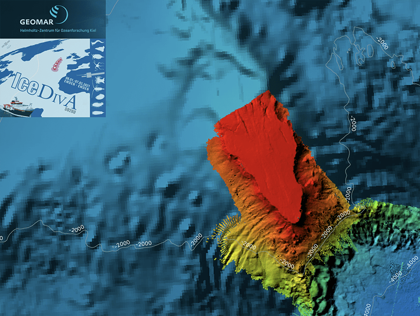
One of the most astonishing structures around is Josephine Seamount, an almost flat-topped, oval-shaped elevation, with a very steep slope on its southern flank. It originally arose as an island
volcano in the Middle Tertiary but became extinct around 9 million years ago. As with all submerged volcanoes, active or not, Josephine Seamount is home to a broad array of marine species. In
fact, Josephine is so unique that it has been declared a Marine Protected Area (MPA) by the OSPAR Commission – an international convention signed and ratified by fifteen member governances for
the protection of the marine environment of the North-East Atlantic. MPAs, as announced by OSPAR, are especially designed to cover areas of high biodiversity and aim to protect those ecosystems,
maintain and improve their current health status, prevent further devastation and exploitation, and to provide a liveable habitat for all marine wildlife. Those areas of protection can be
designated within but also outside the sovereign territory of a governance (exclusive economic zone, usually 200 nm off a State’s coastline). Areas beyond national jurisdiction are called the
High Seas and there are only a few regulations prevalent here. Ships operating in the High Seas are principally under the jurisdiction of their Flag State, but port States may intervene if, for
example, international environmental rules are being violated.
The legal framework concerning the use of marine resources and its resources is provided by the United Nations Committee of the Law of the Sea (UNCLOS), an international agreement on the rights
and responsibilities of nations towards the world’s oceans, which has been ratified by 168 parties. However, this legal structure provides basic directives rather than distinct laws, and
regulations for specific human activities on the High Seas are far less defined. Against this background, establishing MPAs here in areas beyond national jurisdiction (ABNJ) is a delicate matter
and, as all nations have equal rights in international waters, raises a number of difficult questions: Who has the competence and knowledge to designate MPAs in ABNJ?
What are appropriate considerations and on which basis can decisions be made? Who will be in charge of MPA ‘management’ and how can it be achieved so that any activity is in compliance with the regulations? Answering these questions is difficult, not least because there is no uniform definition of what an MPA is. As a common denominator, MPAs essentially have a special status in terms of regulations on human activities in relation to habitat conservation. Yet this does not mean that any activity, for example fishing, is prohibited – it may only mean that certain types of fishing practice are not allowed. Not surprisingly, there is a conflict of interest between legislative committees who designate MPAs and the fishing industry, with the latter presenting significant threats to biodiversity in the High Seas. Cooperation between all involved parties is essential to achieve marine conservation (Molenaar and Oude Elferink, 2009). OSPAR has committed itself to pose and answer those questions and to set up a coherent network of MPAs in waters beyond national sovereignties in the NE Atlantic.
Scientific research in MPAs has to undergo a risk assessment prior to any measurement activity. On the one hand, the designation of MPAs is solely based on scientific knowledge without which
there wouldn’t be a profound decision basis. Additionally, research activities can also pose a threat to the ecosystems if falsely deployed. Sampling ground-truth data with benthic gear always
carries the risk of harming delicate structures like corals or sponges. Depending on the sounding frequency, hydroacoustics can severely disturb the communication of local inhabitants such as
fish shoals as well as of those animals travelling far distances, e.g., the endangered Leatherback turtle, who use seamounts as a stopover to rest and feed. Thus it has to be decided carefully
what sort of research is sensible in order to obtain the necessary knowledge needed to support the case for establishing an MPA.
In our case of Josephine Seamount, we found out that there isn’t a coherent high resolution bathymetry, which is crucial as seabed topography has direct effects on floral and faunal assemblages.
So we decided to spend the last day of our station work mapping this beauty, and this certainly has not been disappointing! Although there is a lot of fishing activity in this area and nearly the
entire plateau has been devastated by former trawling, a complex-looking structure at the slope of our Josephine indicates a potential abundance of coral reefs. However this is a hypothesis
and needs further evaluation to be confirmed.
Meanwhile, we are on our transit back home. The weather conditions have been absolutely fantastic throughout the entire journey so far, but in the next couple of days, we expect storms and high waves. Let’s hope for the best!
On a final note, I would like to express my enthusiasm about this cruise. It has been a full success regarding the scientific achievements, driven by the efforts of every single person on board
of R/V Sonne to keep the daily (and nightly) business up and running. For the last four weeks, we have been blessed with working and living on a floating corona-free island, and we can
consider ourselves very lucky about the circumstances which make this possible. In that sense, I would very much like to say thank you to everybody, crew members and scientists, and especially to
the Captain Lutz Mellon, for whom this is his last cruise before he leaves for retirement. It has been a special honour to meet him and in the name of everyone on board, I wish him all the best
for his future on the solid ground land life!
References:
Erik J. Molenaar & Alex G. Oude Elferink (2009): Marine protected areas in areas beyond national jurisdiction: The pioneering efforts under the OSPAR Convention. URL:
http://www.utrechtlawreview.org/, Volume 5, Issue 1 (June) 2009
OSPAR Commission: Protecting and conserving the North-East Atlantic and its resources. URL:
https://www.ospar.org/work-areas/bdc/marine-protected-areas/mpas-in-areas-beyond-national-jurisdiction
OSPAR Commission (2011): Background Document on the Josephine Seamount Marine Protected Area