There are various good reasons why mapping the seafloor is important – and today, we can prove at least one of them! Many years ago, people thought that the deep sea was a vast and boring place,
primarily flat and full of mud – an inhospitable world where nothing lives or survives. Well, this has been shown to be untrue by numerous scientists and seafarers when they started ‘sounding’
the oceans using lead lines as a first depth measurement around 1850. A couple of years and a lot of lead-line cruises later, those data charted on early seafloor maps showed the outlines of
mid-ocean ridges. In 1912, this led Alfred Wegener to assume that we live on drifting continental plates. What a daring statement! It took no fewer than 50 years, until 1960, that people started
to consider his hypothesis as true. Today, the tectonic movement of continental and oceanic plates is a widely accepted theory and a very hot research topic that is constantly underpinned by new
discoveries. Many of those findings involve ocean floor features, nearly all of which are somehow related to continental drift. Even if being far away from the fresh spreading centres on the
mid-ocean ridges, the ultra-slow tectonic driving forces which literally keep the world going round have effects on the most remote seabed formations.
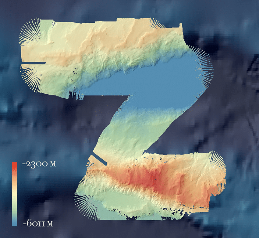
Today, we made such a discovery – whether this can be connected to continental drift still has to be discussed, but one thing is for sure: What we found is an amazing underwater world in the
middle of the abyssal plain – the deep-sea nowhere. On the satellite image it looked like a small but very deep hole situated just off a craggy terrain. Looking at the new bathymetry revealed an
enormous mountain chain, nearly as high as the Alps, arising from 6000m deep ocean flat basin. The surrounding environment is very flat and two-dimensional, as if someone had taken an iron to
flatten the seafloor.
The discrepancy between the satellite-derived bathymetry and the ‘real’ one is related to the acquisition method. Satellite ocean depths are modelled from the earth’s gravity field – the denser (‘heavier’) the subsurface, the larger is its gravitation value. This however means that denser material, for example rocks with a high iron content, also have an increased gravity field. Those areas form bulbs on the water surface which can then be linked to the actual water depth. This is how the shape of the sea bottom is obtained from space. Ship-based bathymetry, on the other hand, is a direct measurement of water depth and thus much more accurate.
Mapping this area wasn’t part of the original planned cruise route, but it came into our view located in the route from the ARGO float area to our next planned working area. In accordance with our slogan, which has been created since the weather conditions demand frequent and spontaneous re-scheduling, we took a little side step to visit this place. And it has been absolutely worth it!
When you encounter such alpine relief in the underwater landscape, it brings the question of which animals live in the 6000m plains, and which on the mountains next to it? Maybe we’ll have some time to discover this at the end of the expedition when we’re on our way back north. Now, we are heading south, right in front of the next storm approaching to catch the time window for our station work. Our motto: Watch out for the good weather periods and be spontaneous, creative and multi-flexible!