
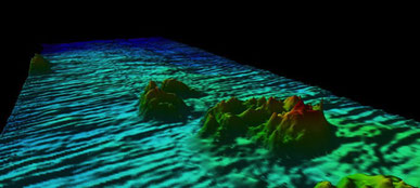
On the fifth day, we start the serious work. Around midnight, we (finally) leave the Norwegian EEZ and now we’re officially allowed to map! So obviously, we would be mapping all night long, sitting in the hydroacoustic lab watching beautiful subsea features and cleaning outliers while listening to the Rolling Stones. But, of course, not without having taken a CTD profile first – because that’s what you do when you arrive at a research station: measure the water parameters, which are the basis for any further operation.

The part that everyone has been waiting for since we left the harbour now arrives: The first launch of the ROV (Remotely Operating Vehicle) ‘Kiel 6000’. This vehicle is a 3.5-tonne heavyweight
giant able to carry numerous different instruments, among which are cameras, traps, drawers to put samples in, spotlights (it’s pitch-dark at 3000m water depth!) and grasping arms, just to name a
few. It’s controlled by two pilots sitting in a container on the deck of RV Sonne, guided by several different cameras on the ROV. One of the pilots, the leader of the ROV team on our cruise, is
Fritz Abegg from GEOMAR – Helmholtz Institute for Ocean Research. The best thing ever is that we have a livestream on YouTube for the ROV dives! Bear witness to true deep-sea life and journey
down to the deep with us in real time: www.youtube.com/SenckenbergWorld


X marks the spot - the current position of RV Sonne in the Norwegian Basin